

 Reply With Quote
I wouldn't go up there now. They are running 88 ft. out of the dams with 50 at the upper and 38 ft. on the lower. The current is going to be very strong and assorted logs and other items will be coming down the river.

| Search Fishin.com |
 Junior Member

We just had a good rain here in Louisville, and the downstream gauge is at 29' at Mcalpine. I've never fished downstream of Mcalpine lock and dam, but have always wanted to. I'm not talking about getting right up by the hydros or lock, but somewhere maybe by the boat ramp on the IN side, or around that area to cast some live bait with a bobber. I have a 25' cabin cruiser that I was hoping to just anchor up somewhere and fish relaxing like. Is this possible in that area?
I searched on here for Mcalpine fishing, and there were some talk of shallow water with many hazards like rocks and such, but are those closer to the hydros?
Member
I wouldn't go up there now. They are running 88 ft. out of the dams with 50 at the upper and 38 ft. on the lower. The current is going to be very strong and assorted logs and other items will be coming down the river.
Junior Member
Maybe I'll wait for a better day for my first trip down there. When the current isn't so strong, would what I mentioned above be achievable for a boat of my type? I don't want any rock hazards, and I don't care to be right up fighting the rapids and current all day.Originally Posted by fishraker

Maybe I'll stick around home and hit the mouth of 14 mile creek or something. Haven't really had a chance to find any good fishing spots on the river from Charlestown, IN to Louisville. Any recommendations would be greatly appreciated.
Senior Member
I think if I was going to take any chances with a boat like your are describing; I would get a topographic map of the section of the river you are interested it.
You might consider going with someone once or twice up that way in a shallower draft boat, and watch their depth finder to get familiar with the area.
When the river calms down some, I think the place you'd have the biggest concern with would be during the run up along side the locks where you make the slight left and start up the slew. Most of the way up the slew should be no problem, but just as you get to where you are going to turn a slight right toward the dam, there is a rift and current break that tends to be quite shallow. On this video, scroll to the 4:45 to 5:15 part of the film, and you'll see the rift I'm talking about. Hybrid Fishing Below McAlpine Dam - YouTube
Pics below are map showing about where rift is, then a pic running the slew just at the rift, then looking back toward the side of the locks, and what the water looks like running thru. This was a December trip when the dam looked like the last pic.
Junior Member
Thanks for the info, Bob. I would love to go with someone more knowledgeable about fishing this area, but I've only been in town for 5 years, and don't know anyone else with a fishing boat or true avid anglers that know the area.
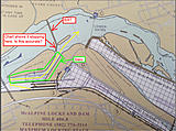
I looked at your pictures, and pulled out the nav chart for that area and marked it up. Is the rift that you're talking about where the dike is shown on the chart? It shows it stopping leaving the little canal open. Is this what you're talking about when you say the slew? The yellow line shows the path of travel coming out of the lock. I guess right where the arrow head is at is where I'd think about dropping anchor and fishing if that's advisable.
Junior Member
(won't let me edit my previous post)
http://stampphotographics.com/photos/Temp/Mcalpine.jpg
 Senior Member
Before I took a 25ft boat up any further than the railroad bridge I would definetly have someone take you up there. There are so many things down there to know about it's not worth taking the chance. I have been fishing that area for 40+ years and it can get very dangerous real quick. Like Bob said the top of the shute get's into skinny water on the left side, stay close to the right side. Then there's the under water pipe on the right side of the hydro's,Wave rock, lock discharge area, two rock islands that can be just underwater, Sunk barge ,sunk truck and on and on. It is truly a very unique fishing area that is just as dangerous.I'm down there ussually every Fri. and would be glad to show you around. Just PM me when the water get's down and we'll go from there. I hope this helps, Good luck up at 14 mile.Chuck
Junior Member
Chuck, I will most likely be in contact with you. I'd love to get the ins and outs of the place from someone who knows it well. Thanks for the help, everyone. By the way, 14 mile creek was uneventful, but truth be known, I really just wanted to get the boat in the water and try out the new fish finder.Can't wait until it really warms up.
-Tim
Posting Permissions