

 Reply With Quote
Navionics with community updates will have the contours correct due to the sonarcharts being recorded by many, many folks.

| Search Fishin.com |
 Junior Member

I'm looking for an accurate contour map of this lake. I bought the 20 ft contour map they sell at the baitshops and I have it on my Navionics Map. These two maps basically contradict each other in various key spots and I would love to see an updated map of the contours with some key features and spots. Any suggestions would be helpful.
Thanks
GeoFisher liked this post
 Senior Member
Navionics with community updates will have the contours correct due to the sonarcharts being recorded by many, many folks.
 Member
This may be the same map you've already seen, but try this website.
http://fishing-app.gpsnauticalcharts....4740/-84.5471
 Administrator
[QUOTE=GreenGhostMan;564152]This may be the same map you've already seen, but try this website.
http://fishing-app.gpsnauticalcharts....4740/-84.5471[/QUOTE
That is one heck of a site for contour maps. I wonder what that phone app is they sell on their front page is like?
Member
Yea, that website is amazing. There are a few small lakes around me I wish they had, but I can't complain since it's free. The amount of water on there is incredible.
Downloading the app is free. It has the same maps and info as the website, but you have to pay to unlock sections of the country. They give you one free section of your choice. The section I chose includes most of western KY and southern IN. Everything east of KY Lake and Lake Barkley (but not including KY Lake and Lake Barkley) and west of I-75 and then southern IN. This is all I really need right now, so it's definitely worth it for me.
Senior Member
Well Hells Bells......I just went out to webapps.navionics.com and Cedar looks like CRAP.......total CRAP.Originally Posted by GeoFisher

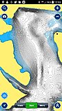
But the charts on my navionics app on my phone are awesome....here is an example:
Senior Member
[QUOTE=peter;564159]I will let yo know.......I just downloaded it
Senior Member
[QUOTE=GeoFisher;564175]It looks GREAT for navigation......but is missing a whole lot of detail for fishing.
I pulled up side by side the navionics phone app for android and this with one tile on KY Lake.......
Navionics BLOWS it away............
IMHO.
Administrator
[QUOTE=GeoFisher;564176]Yeah. the navionics iphone app has very detailed contour maps and is real nice for navigating rivers also. It's free too! I did do a fifteen dollar or so upgrade on the app but not sure it is at all necessary.
Thanks for checking out the gpsnauticalcharts app.
I put some velcro on the back of my phone and on the bottom of my graph so I can stick it there and keep my hands free. Works great!
Posting Permissions